Monday 17 February 2014

PENTLAND HILLS ...wee sunday stroll

wyczekiwana swietna pogoda wreszcie nadeszla... I trudno sie dziwic ze wszyscy od razu wyszli z domu... I trudno sie dziwic ze takie tlumy zalaly dzis pentlandy :) a ja wraz z nimi :)

(flotterstone - turnhouse hill -glencorse)

.
.

long awaited good weather came today ... and no wonder everybody went outside instantly.. and no wonder the pentlands were sooooo crowded today :)

(flotterstone -turnhouse hill - glencorse)


Sunday 16 February 2014

CRAMOND evening photties

cramond :)


HOLBORN HEAD

ostatni dzien naszej wycieczki na 'daleka polnoc' szkocji. niestety juz nie tak slonecznie I nie az tak ciekawie, choc wciaz niezgorzej :)
wybralysmy sie na Holborn head by zobaczyc jeszcze jakies inne rodzaje ostancow oraz przejsc sie skalistym klifowym wybrzezem. strasznie wialo, naprawde bardzo tak wiec niestety nawet nie zblizalysmy sie zbytnio do krawedzi klifow :(
Holborn head znajduje sie w odleglosci (podobno) 30 minut spaceru od thurso (tak mowil nasz gps, samochodem jechalysmy doslownie 5 minut). nalezy udac sie do malej miejscowosci scrabster, zostawic samochod przy przystani (parking darmowy- sa maszyny do 'pay and display', ale nie dzialaja poza sezonem, tak mi sie zdaje). od przystani do latarni idzie sie okolo 10 minut, od latarni wzdloz wybrzeza - jak dlugo I daleko dusza zapragnie.
mapa pokzauje kilkanascie ostancow wzdloz tego wybrzeza, ale jak wspomnialam strasznie wialo wiec my wybralysmy sie tylko do pierwszego.
... no a w scrabster zaczyna sie A9, ktora od poczatku do konca (perth) przejechalysmy w drodze do domu. warunki na drodze zmienily sie z 'lato' na 'zima' na wysokosci inverness wiec droga powrotna zajela nam okolo 6 godzin....


.
.
.
the last day of exploring Scottish 'far north', unfortunately not as sunny as previous days and not that interesting, although still worthwhile.
Holborn head was the last place we visited, a promise of more sea stacks and nice rocky cliffy coast. too bad, as the wind was amazingly strong and we didn't dare to approach cliff edge :(
Holborn head is 30 mins walk from thurso (at least this is what my gps said, driving -5 mins).
how to get there: from thurso drive 5 mins to scrabster and leave the car at the harbour (free car park outside -the season). from harbour walk about 1 mins to the lighthouse, from the lighthouse explore the coast as much as you like. the map shows about a dozen seastacks, but as I already mentioned -the wind was too strong and we walked to the first one only.
... also in scrabster the A9 starts, therefore we drove it from the very beginning to the very end (perth). in inverness weather conditions changed from 'summer' to 'winter' so the drive back home took about 6 hrs...


map copyright ordnance survey


Holborn head lighthouse


Holborn head point


dziury w klifach   /  holes in the cliffy coast


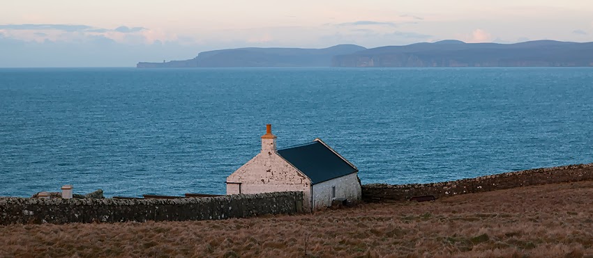
w oddali dunnet head   /    dunnet head in the distance


Saturday 1 February 2014

DUNNET HEAD

dunnet head jest najbardziej na polnoc wysunietym zakatkiem szkocji. coprawda badac na dunnet head, zdaje sie ze wybrzeze dalej na zachod jeszcze bardziej wchodzi w morza, ale mapa jest nieublagana - dunnet head I koniec.
przyjechalysmy na ten cypelek zaraz przed zachodem slonca. nie ma tu duzo chodzenia - najwyzszy punkt w okolicy to spacer 10 minut a niestety widoki sa slabe. w sumie najlepszy widok jest wlasnie z parkingu przy latarni.
w dunnet head przekonalysmy sie dlaczego na bramach wjazdowych do latarni zawsze jest napisane zeby trzymac sie z daleka I nie szwedac sie po terenie I zabudowaniach. nie wiem jak inne latarnie, ale ta w dunnet head byla nieco dziwna I roztaczala aure jak w thrillerze. brama byla otwarta wiec nie zastanawiajac sie szybko podeszlysmy pod sama latarnie, szybko bo spodziewalam sie ze zaraz ktos nas wyprosi. kilka fotek cyknietych I wtedy wlasnie zaczelysmy 'wchlaniac' atmosphere miejsca I zauwazylysmy ze drzwi do wszystkich budynkow byly otwarte. za latarnia rozpoadal sie jakis stary wpol rozwalony samochod. gdziekolwiek nie zajrzalysmy przez drzwi czy okno - pomieszczenia byly zdemolowane... a jednak brama byla otwarta wiec ktos tam musial w tej chwili przebywac. nagle ogarnelo mnie uczucie jak z thrillera - ze zaraz jakis szaleniec sadysta wyjdzie przez pobliskie drzwi, zlapie nas I bedzie torturowac tygodniami. szybko wzielam beate I 'wylecialysmy' stamtad wciaz ogladajac sie za siebie hihihihi


.
.
.

dunnet head is the tiny piece of land which, as map says, is most northerly land of Scottish/british mainland. looking further to the west I was sure that there are more northerly lands there, but the map is clear - dunnet head it is.
we visited it just before sunset. there isn't much walking around - the highest point of the head is only 10mins away (from the car park) and still, the view isn't too awesome. actually the best views are from the car park just at the lighthouse.
in dunnet head we found out why they always ask to keep out from lighthouse itself. the dunnet head lighthouse was very dodgy. the gate was open so without a single thought, we went in. walked to the lighthouse itself, took some pics and only then we realised what surrounded us. door to every building was open, looking thru the door or windows all we saw was total mess, interiors totally demolished. at the back of the lighthouse was an old car, falling apart. seeing this I suddenly got a feeling like in a thriller movie- in a minute someone will emerge from the door and try to catch us, keep us there and torture  lol
VERY QUICKLY we made out way out..
really dodgy place


gory na zachod od dunnet head   /   looking west


w tle jedna z wysp nalezacych do orknejow - hoy. widac nawet ostanca old man of hoy, z lewej
in the background -hoy, Orkneys. actually you can see the old man of hoy, on the left


piekny zachod slonca z hoy w tle
amazing sunset with hoy highlighted by a warm setting sun